
Urban Tree Counting: How GIS, Remote Sensing & AI Improve Urban Forestry
Urban Tree Counting: Modern Methods for Smarter Urban Forestry
Between 2009 and 2014, U.S. cities lost about 36 million trees each year, reducing urban tree cover by 0.7%. To understand the value trees provide and manage growing urban canopies, arborists and city teams need accurate, up-to-date data. Manual surveys are slow, inconsistent, and no longer sufficient.
A new approach to Urban Tree Counting is transforming how cities collect and use tree data. Tools like high-resolution aerial imagery, LiDAR, and machine learning make inventories faster, more accurate, and more cost-effective. For teams in Canada and the U.S., these modern methods improve data quality, guide budget planning, and strengthen urban forestry programs.
What Urban Tree Counting Is and Why Cities Need It
Urban tree counting is the process of determining the number, location, and condition of trees in a city using manual surveys or remote sensing technologies such as satellite imagery, LiDAR tree mapping, drones, and AI.
Why This Data Matters
For arborists and city planners in North America, high-quality urban forestry data is essential because it quantifies the real benefits urban forests provide:
-
Climate resilience & cooling: tree inventories help calculate cooling effects and identify low-canopy areas most affected by heat, supporting targeted planting that improves public health.
-
Air quality: knowing species and canopy size allows cities to estimate how much pollution their trees remove – valuable evidence when applying for climate and environmental funding.
-
Stormwater management: tree data is used to measure how much rainfall the canopy intercepts, which reduces runoff and lowers pressure on drainage systems.
-
Biodiversity: species-level data shows how diverse the urban forest is and guides planting choices that support local wildlife and long-term ecological stability.
Why Cities Need an Accurate Urban Tree Inventory
With rising climate risks and tight budgets, cities need a clear, detailed picture of their urban forests:
-
Proactive risk management: inventories identify declining or hazardous trees early, helping arborists plan maintenance, pruning, and removals before problems escalate.
-
Asset valuation: trees can be valued as municipal assets. Knowing their condition and contribution helps shift trees from being seen as costs to recognized infrastructure.
-
Better budgeting & policy: accurate data supports defensible budgets, staffing needs, planting targets, and maintenance cycles – ensuring resources are used efficiently and fairly.
Main Challenges in Collecting Tree Data
Cities still face major obstacles in keeping their tree inventories accurate and up to date. These challenges limit effective planning, budgeting, and long-term canopy management.
Outdated and Fragmented Records
Many inventories rely on old or inconsistent urban forestry data spread across paper files, spreadsheets, and mismatched GIS layers. Because updates happen slowly, information on species, condition, and DBH often becomes outdated within months.
Slow, Labor-Heavy Field Surveys
Traditional ground surveys are time-consuming, expensive, and difficult to scale. Safety risks and limited access to private property also create gaps that reduce the accuracy of canopy assessments.
Limited Resources and Skilled Staff
Urban forestry teams frequently work with tight budgets and not enough GIS-trained personnel. This makes it challenging to adopt modern tools like LiDAR or high-resolution imagery.
Rapid Urban and Environmental Change
Construction, redevelopment, storms, pests, and drought change the canopy faster than manual surveys can track. As a result, inventories quickly fall out of date, limiting their value for risk management and planning.
Modern Methods of Urban Tree Counting
Modern urban forestry across Canada and the U.S. is shifting from slow, manual surveys to faster and more scalable technologies. Each method offers specific advantages, and cities get the best results by combining several approaches to balance accuracy, efficiency, and cost.
| Method | Strengths | Limitations | Best use cases |
|---|---|---|---|
| Manual inventory (ground surveys) | Highest accuracy for assessing condition, defects, pests, diseases, and DBH | Very slow and costly; not scalable for full-city inventories | High-value trees, risk mitigation zones, auditing remote-sensing data |
| Satellite imagery | Fast, affordable citywide canopy updates; useful for tracking canopy cover trends | Limited ability to identify individual trees | Benchmarking canopy cover, monitoring large areas regularly |
| LiDAR | Detailed 3D structure; accurate height, crown size, and individual crown separation | Requires specialized processing; higher cost | Precise canopy structure mapping, advanced modeling, large municipal inventories |
| Drones + AI tree detection | High-detail imagery; automated counting, species classification, and size estimates | Best for targeted areas; may be costly for very large regions | Neighborhood-level inventories, frequent updates, high-accuracy mapping |
| Citizen science | Low-cost data expansion; strong community engagement; access to private properties | Requires professional review for accuracy | Filling data gaps, public participation, complementing professional inventories |
Data Collected During a Tree Inventory
A modern urban tree inventory provides far more value than a simple tree count. For arborists across Canada and the U.S., standardized, high-quality data is essential for planning, budgeting, predictive modeling, and reporting on canopy health and performance.
| Data Metric | Description | Value to arborists |
|---|---|---|
| Location (GPS coordinates) | Precise latitude and longitude for each tree. | Enables GIS mapping, tracking maintenance history, and quick navigation for field crews. |
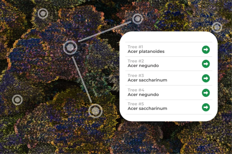
| Species identification | Common and scientific name (e.g., Acer platanoides). | Crucial for assessing biodiversity, identifying susceptibility to species-specific pests (e.g., EAB, Asian Longhorned Beetle), and planning native plantings. |
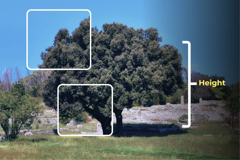
| Diameter at breast height (DBH) & height | DBH (measured at 4.5 ft / 1.37 m) and total tree height. | Fundamental inputs for calculating Biomass and Ecosystem Services (e.g., carbon storage, stormwater interception) using models like i-Tree. |
| Tree management | A categorical rating (e.g., Excellent, Good, Fair, Poor, Dead) of the tree’s overall structure and vitality. | Guides immediate maintenance priority and informs long-term planting/removal schedules. |
| Canopy size / spread | Measurement of the crown diameter (often North-South and East-West). | Used to calculate Leaf Area Index (LAI) and canopy cover, directly correlating to shade provision and cooling capacity. |
| Health indicators | Specific observable signs like insect infestation, pathogen presence, foliar issues (chlorosis), or mechanical damage. | Triggers focused intervention for pest and disease management programs. |
| Risk rating | A formal assessment of the likelihood and potential consequence of tree failure (often using methodologies like ISA’s Tree Risk Assessment). | Essential for minimizing public liability and prioritizing high-risk removals or mitigation efforts. |
| Associated photos | Geo-tagged photographs of the tree's trunk, crown, or specific defects. | Provides visual documentation for quality control, risk assessment reporting, and communicating maintenance needs to stakeholders. |
| Urban planning | Tree data integrated into municipal or development planning workflows. | Helps planners optimize green space allocation, manage conflicts with infrastructure, and support sustainable city design. |
| Environmental analysis | Use of tree data to measure ecosystem function and environmental value. | Supports carbon accounting, heat island mitigation studies, air quality modeling, and stormwater management planning. |
| Monitoring changes over time | Tracking how tree metrics evolve through repeated inventories. | Enables detection of declines, growth trends, hazard development, post-storm impacts, and long-term canopy progression. |
Collecting these detailed, geo-referenced attributes transforms the urban forest into a managed green infrastructure asset, empowering arborists to make data-driven decisions that enhance canopy value and community safety.
How GIS Turns Tree Data Into Useful Insights
Geographic Information Systems (GIS) are central to modern urban forestry, turning urban tree inventory data into actionable insights. By mapping tree locations, species, and condition, GIS tree mapping helps arborists track maintenance needs, identify pest outbreaks, and locate low-canopy neighborhoods for targeted planting.
GIS also integrates canopy data with urban datasets, allowing cities to pinpoint heat hotspots, prioritize plantings, manage stormwater, and plan green infrastructure. This spatial insight supports stronger tree policies and demonstrates the economic and environmental value of the urban forest.
With GIS, arborists can manage trees strategically, treating the urban forest as vital city infrastructure for resilience, equity, and sustainability.
Benefits of Modern Urban Tree Counting
Modern, data-driven Urban Tree Counting offers high-value benefits that strengthen urban forestry and city resilience across Canada and the U.S.
Enhancing Climate Resilience
Using LiDAR and high-resolution imagery, arborists can measure canopy size, crown volume, and Leaf Area Index (LAI). This helps cities plant trees strategically to reduce the Urban Heat Island effect, protect vulnerable populations, and provide reliable data for carbon sequestration reporting in municipal climate plans.
Improved Stormwater Management
Accurate tree data supports hydrological modeling to show how canopy intercepts rainfall, reducing runoff and protecting infrastructure. This evidence helps justify green infrastructure investments, saving costs on grey infrastructure upgrades.
Public Health and Equity
GIS and drone-based tree inventory data highlight low-canopy areas and tree equity gaps, enabling targeted planting in underserved neighborhoods. Knowing tree species and distribution also improves modeling of air pollutant removal, supporting healthier communities.
Risk Identification and Pest Management
High-resolution imagery and AI flag stressed or hazardous trees, allowing arborists to focus inspections where they are most needed. Rapid re-inventory after pest invasions (e.g., Emerald Ash Borer) enables swift, large-scale response.
Tracking Tree Loss and Planting Success
Frequent, accurate inventories provide a real-time picture of canopy health. Arborists can monitor tree loss, evaluate planting success, and refine species selection and techniques to meet net-canopy goals.
Real-World Applications
Modern Urban Tree Counting gives Canadian and American arborists practical, real-world data that supports proactive, strategic urban forest management.
Prioritizing Planting Efforts
Modern GIS-based inventories show exactly where canopy is low, heat stress is high, and communities are underserved. This helps arborists direct planting to equity zones and high-impact areas near schools, hospitals, and pedestrian corridors.
Monitoring Canopy Gain and Loss
Frequent satellite or aerial updates allow cities to track canopy change with precision. Arborists can compare annual loss to new plantings, measure progress toward net-gain goals, and evaluate whether tree protection policies are effective.
Early Detection of Stressed Trees
Multispectral imagery and AI highlight drops in canopy health before symptoms appear. This early warning helps crews intervene sooner, protect high-value trees, and reduce costly emergency work.
Supporting Policy and Sustainability Goals
Modern inventory data provides clear metrics – such as CO₂ storage and stormwater benefits – that strengthen municipal policies and are often required for major federal or provincial grant applications.
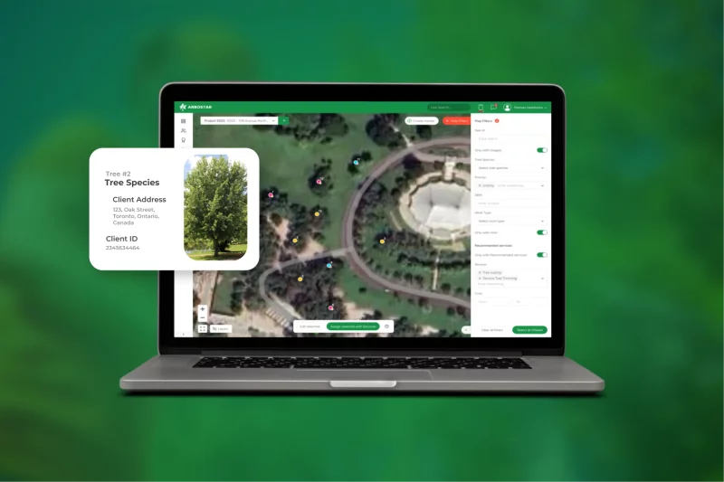
How Arbostar Helps with Tree Inventory Workflows
Software platforms like ArboStar help Canadian and American arborists turn modern tree inventory data into practical, day-to-day action. ArboStar serves as a central hub that connects field data, mapping, and operations into one streamlined system.
Seamless Data Collection and Mapping
ArboStar lets field crews collect standardized data directly in the mobile app – no paper forms or manual entry. GPS-based mapping records each tree's exact location, while photos and structured fields (species, DBH, condition, risk rating) ensure every record is complete and consistent.
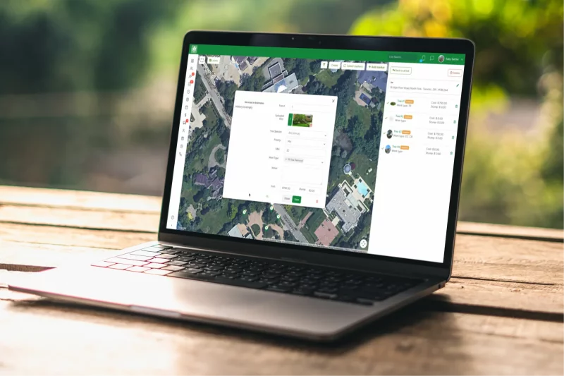
From Inventory to Automated Workflows
Inventory data flows directly into scheduling and work order management. Risk scores help teams prioritize urgent trees, and crews receive detailed work orders linked to each tree's map location, history, and photos, improving accuracy and efficiency on the ground.
Comprehensive Long-Term Asset Management
The platform stores a full digital history for every tree, supporting long-term health monitoring and liability protection. Built-in reporting tools help arborists measure canopy health, track maintenance costs, and demonstrate the value of urban forestry investments to municipal leaders.